

0


| Thumbs Up |
| Received: 3,787 Given: 2,516 |
the Only one in the Usa similar to Florence, my city; is:
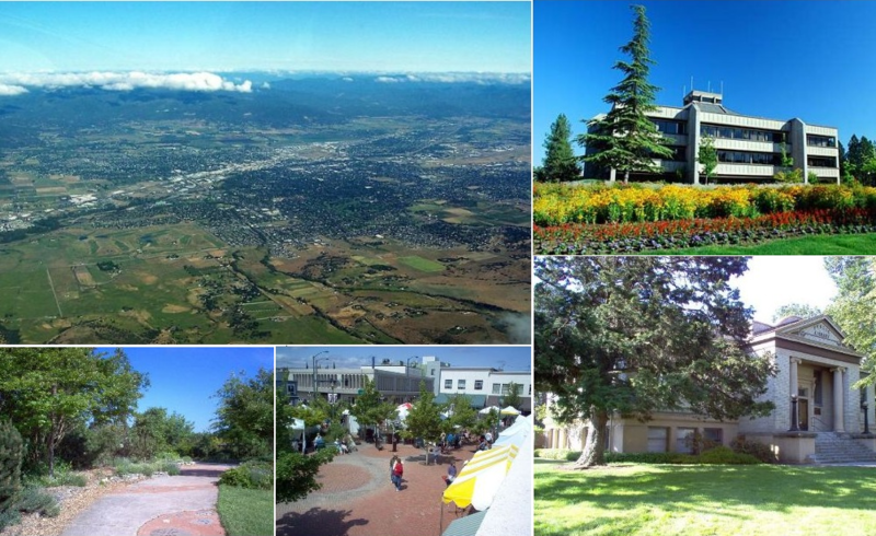
MEDFORD, OREGON lat 42,19 pop. 75,000
Medford sits in a rain shadow between the Cascade Range and Siskiyou Mountains called the Rogue Valley. As such, most of the rain associated with the Pacific Northwest and Oregon in particular skips Medford, making it drier and sunnier than the Willamette Valley. Medford’s climate is considerably warmer, both in summer and winter, than its latitude would suggest, with a Mediterranean climate (Köppen Csa). Summers are akin to Eastern Oregon, and winters resemble the coast. Here, summer sees an average of 57 afternoons over 90 °F or 32.2 °C and eleven afternoons over 100 °F or 37.8 °C. In August 1981, the high temperature reached over 110 °F or 43.3 °C for four consecutive days, with two days reaching 114 °F or 45.6 °C. Freezing temperatures occur on 69 mornings during an average year, and in some years there may be a day or two where the high stays at or below freezing; the average window for freezing temperatures is October 23 through April 23. The city is located in USDA hardiness zone 8. Medford also experiences temperature inversions in the winter which during its lumber mill days produced fog so thick that visibility could be reduced to less than five feet. These inversions can last for weeks; some suggest this is because the metropolitan area has one of the lowest average wind speeds of all American metropolitan areas. The heavy fog returns nearly every winter with the inversions lowering air quality for several months without relief.
Medford residents do experience snowfall during the winter months; however, due to the weather shadow effect it only averages 3.6 inches or 0.09 metres and melts fairly quickly. In the past, the city has seen seasonal snowfall totals reach 31 inches or 0.79 metres in 1955–1956.[38] That season was also the wettest “rain year” with a total of 33.41 inches (848.6 mm); this immediately followed the driest “rain year” since records started in 1911 from July 1954 to June 1955 when only 9.28 inches (235.7 mm) was recorded. By far the wettest month has been December 1964 with 12.72 inches (323.1 mm); no other month has had more than 10 inches or 254 millimetres
more South lies this City: REDDING, CALIFORNIA lat 40,35
Despite its relatively high latitude at 40°N, Redding has a hot-summer Mediterranean climate (Köppen: Csa), with hot, dry summers and mild, wet winters. Winter (October–April) provides the most precipitation of any season in Redding—the weather tends to be either rainy or foggy and at times, snow occurs. Summers are hot and dry, but rain is possible, usually with a thunderstorm. The average daily maximum temperature in July stays near 100 °F (38 °C). The highest official recorded temperature in Redding was 118 °F (48 °C) on July 20, 1988. That was recorded at the nearby Redding airport. Some people in town recorded as high as 122 °F (50 °C) that same day. Redding has an average possible sunshine of 88%, the second-highest percentage (after Yuma, Arizona) of any US city.
While snow in Redding has become less common, the city receives an average of 4.8 inches (12 cm) of snow annually. It rarely gets sleet or freezing rain. Frost occurs commonly in December through February, less often in March or November. Redding can have chilly to cold winters like the rest of the Central Valley to the south. In spring, rain is common. Tornadoes are extremely rare; flooding occurs only around the area near the Sacramento river.
Last edited by GiCa; 03-25-2017 at 06:12 PM.


| Thumbs Up |
| Received: 0 Given: 0 |
According to service http://www.vividmaps.com/p/cities-wi...-climates.htmlOriginally Posted by GiCa

Cities with similar climates: Jinan (China), Zhengzhou (China), Daegu (South Korea), Zaozhuang (China), Xuzhou (China), Linyi (China), Nanyang (China), Shuyang (China), Shangqiu (China), Taian (China), Florence (Italy), Gwangju (South Korea), Heze (China), Huaiyin (China), Jining (China), Ulsan (South Korea), Xinyi (China), Tulsa (USA), Huaibei (China), Richmond (USA), Nashville (USA), Kaifeng (China), Pingdingshan (China), Yancheng (China), Shiyan (China), Lianyungang (China), Knoxville (USA), Taizhou (China), Bologna (Italy), Xuchang (China), Pohang (South Korea), Luohe (China), Wichita (USA), Greensboro (USA), Zhoukou (China), Maebashi (Japan), Durham (USA), Winston-Salem (USA), Mokpo (South Korea), Chattanooga (USA), Pisa (Italy), Kofu (Japan), Kutaisi (Georgia), Weinan (China), Baramula (India), Elbasan (Albania), Fayetteville (USA), Hanzhong (China), Jieshou (China), Clarksville (USA), Ferrara (Italy), Petersburg (USA), Columbia (USA), Murfreesboro (USA), Ancona (Italy), Hickory (USA), Pingyi (China), Shanxian (China), Joplin (USA), Bowling Green (USA), Sopore (India), Pula (Croatia), Lankaran (Azerbaijan), Dalton (USA), Kingsport (USA), Parachinar (Pakistan), Stillwater (USA), Berat (Albania), Enid (USA), Danville (USA), Salisbury (USA), Paducah (USA), Cape Girardeau (USA), Hopkinsville (USA), Bartlesville (USA), Oak Ridge (USA), Ponca City (USA), Madisonville (USA), Poplar Bluff (USA), Burrel (Albania), Coffeyville (USA), Gramsh (Albania), Permet (Albania)
| Thumbs Up |
| Received: 0 Given: 0 |
Cities with similar climates: Ankara (Turkey), Tabriz (Iran), Yerevan (Armenia), Konya (Turkey), Hamadan (Iran), Eskisehir (Turkey), Huancayo (Peru), Zanjan (Iran), Boise (USA), Neyshabur (Iran), Kirikkale (Turkey), Corum (Turkey), Malayer (Iran), Salamanca (Spain), Afyon (Turkey), Maragheh (Iran), Quchan (Iran), Comodoro Rivadavia (Argentina), Caldwell (USA), Tokat (Turkey), Karaman (Turkey), Pueblo (USA), Medford (USA), Grand Junction (USA), Kennewick (USA), Kirsehir (Turkey), Polatli (Turkey), Eregli (Turkey), Nigde (Turkey), Cankiri (Turkey), Wenatchee (USA), Lewiston (USA), Walla Walla (USA), Richland (USA), Farmington (USA), Villazon (Bolivia), Toktogul (Kyrgyzstan), Zapala (Argentina), Pendleton (USA), Ontario (USA), Chuquicamata (Chile), Malargue (Argentina), Humahuaca (Argentina), Puquio (Peru)


| Thumbs Up |
| Received: 2,268 Given: 1,561 |
There are two climate freaks in this forum: me and GiCa.
| Thumbs Up |
| Received: 3,787 Given: 2,516 |
Those above are not really transition Cfa-Csa
They are pure Cfa or pure Csa


| Thumbs Up |
| Received: 20,923 Given: 18,997 |
There are currently 1 users browsing this thread. (0 members and 1 guests)
 Italia
 France
 Posting Permissions


 Reply With Quote
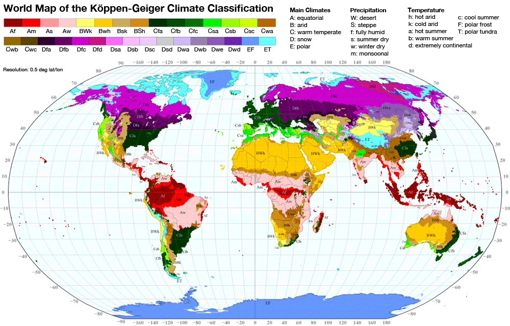
Bookmarks