


 United States
3


| Thumbs Up |
| Received: 28,799 Given: 25,904 |


| Thumbs Up |
| Received: 13,201 Given: 9,778 |
Not that anyone on here is gonna care,but I feel the need to point it out anyway.
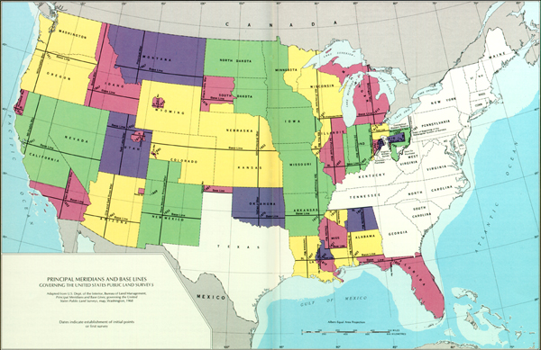
The states in the western half of the US are generally more square because that's when they started doing regular land surveys,as opposed to the old European system.
| Thumbs Up |
| Received: 28,799 Given: 25,904 |
You can also tell when the area was settled just looking at the farm formations. In the West, the farms are huge and very linear. While in the East Coast, they are far smaller and less uniform. Obviously they were tilled before the advent of modern cartography and with smaller units of organization.Originally Posted by Profileid


| Thumbs Up |
| Received: 23,081 Given: 56,859 |
A lot of it has to do with terrain. I mean, the midwest is pretty flat and is very much divided by squares. The more mountainous and hilly regions are less so. As you can see comparing the westernmost states..


| Thumbs Up |
| Received: 302 Given: 28 |
Every state's border is interesting and unique in some ways.
| Thumbs Up |
| Received: 28,799 Given: 25,904 |
That and also, the East Coast was settled piecemeal. While the settlement of the mountainous West, the bulk of the Louisiana Purchase along with the territories acquired after the Mexican American war, was essentially organized by the US government.
| Thumbs Up |
| Received: 13,201 Given: 9,778 |
Yes. The old survey system was known as metes and bounds and they would chart everything by landmarks like rocks or rivers,like in the vid, which made it very irregular.
In Lousiana, the parishes were originally divided by the rivers,but as the courses changed,they still kept the boundaries.

| Thumbs Up |
| Received: 28,799 Given: 25,904 |
You're a fucking nerd.
| Thumbs Up |
| Received: 13,201 Given: 9,778 |
lol but colorado is literally a square though
im actually not sure what the reason is. but the surveying system they used later on was literally based on squares
| Thumbs Up |
| Received: 28,799 Given: 25,904 |
Yeah I wish they could've been more creative. Colorado and Wyoming look wack.
Look at this county map of Massachusetts, they actually look like they were forged through struggle.

There are currently 1 users browsing this thread. (0 members and 1 guests)
 United Kingdom
 Posting Permissions

 Reply With Quote
Bookmarks