

1


| Thumbs Up |
| Received: 25 Given: 0 |
Do you like maps? I like maps. Osweo likes maps. And that's reason enough.
This thread is for interesting maps. Old maps, new maps, historical maps, linguistic maps, battle maps, archeological maps...I just want to see some interesting maps.
PLEASE PUT ALL MAPS IN SPOILER TAGS!
Argow cum parte merid Zurichgow
Spoiler!
Das Wiflispurgergow
Spoiler!
Alsatia
Spoiler!
Palatinus ad Rhenum
Spoiler!
Zurichgow et Basiliensis provincia
Spoiler!
Rhenus
Spoiler!
Last edited by Electronic God-Man; 04-19-2010 at 04:18 AM.
| Thumbs Up |
| Received: 25 Given: 0 |
Helvetia
Spoiler!
Palatinus Rheni
Spoiler!
16th Century Southwest Germany
Spoiler!
18th Century Southwest Germany
Spoiler!
Alemannic Settlements about 450 and about 600
Spoiler!
Celts - Close-up of Southwest Germany
Spoiler!
Last edited by Electronic God-Man; 04-19-2010 at 04:17 AM.
| Thumbs Up |
| Received: 25 Given: 0 |
Bishoprics and Monasteries in Southwest Germany - Middle Ages
Spoiler!
Religions in Southwest Germany at the time of the Reformation
Spoiler!
Romans in Southwest Germany
Spoiler!
Staufer, Welfen and Zaehringer lands in Southwest Germany
Spoiler!
Thirty Years War - Southwest Germany
Spoiler!
Last edited by Electronic God-Man; 04-19-2010 at 04:14 AM.
| Thumbs Up |
| Received: 92 Given: 0 |
[SPOILER=Transylvania - form Theatrum Orbis Terrarum, sive Atlas Novus in quo Tabulæ et Descriptiones Omnium Regionum, Editæ a Guiljel et Ioanne Blaeu, 1645][/SPOILER]
[SPOILER=The Grand Duchy of Transylvania, 1773][/SPOILER]
[SPOILER=The Transylvanian Principality in 1857][/SPOILER]
[SPOILER=Map of Hungary, Galicia, Transylvania, Bukowina, Croatia and Slavonia, 1862][/SPOILER]
[SPOILER=The Vlach (Romanian) population in Hungary according to the census from 1890][/SPOILER]
[SPOILER=Map of the Austro-Hungarian territories inhabited by Romanians][/SPOILER]
[SPOILER=La fîntînă la mocrină][YOUTUBE]ecSLcemo3dI[/YOUTUBE][/SPOILER]
| Thumbs Up |
| Received: 92 Given: 0 |
[SPOILER=Romanian political entities (states) in the IX - XIII centuries][/SPOILER]
[SPOILER=Migration routes of Hungarians, Bulgarians, Pechenegians, Cumanians and the great Tartar invasion on Romania's territory during the VII-XIII centuries][/SPOILER]
[SPOILER=Map of Romania with the administrative units of 1879][/SPOILER]
[SPOILER=Romanians living outside Romania before 1918][/SPOILER]
[SPOILER=Ethnic map of Romania, 1930][/SPOILER]
[SPOILER=Ethnic map of Romania, 2002][/SPOILER]
[SPOILER=La fîntînă la mocrină][YOUTUBE]ecSLcemo3dI[/YOUTUBE][/SPOILER]
| Thumbs Up |
| Received: 25 Given: 0 |
Britain 1200-1450
Spoiler!
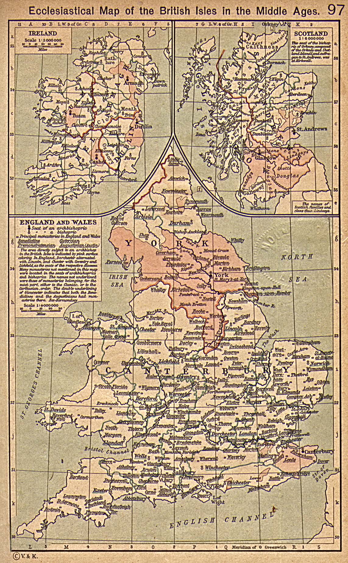
Ecclesiastical Map of the British Isles during the Middle Ages
Spoiler!
England 1087-1154
Spoiler!
England during the Reign of Edward the Elder
Spoiler!
England in the 8th Century
Spoiler!
Lancastrian and Yorkist Estates in England, 1455-1485
Spoiler!
| Thumbs Up |
| Received: 25 Given: 0 |
Southern England, c. 1000 during the Reign of King Aethelred the Unready
Spoiler!
Southern England in the Eighth Century
Spoiler!
Political Development of Anglo-Saxon England
Spoiler!
Map of England (showing select abbeys)
Spoiler!
| Thumbs Up |
| Received: 25 Given: 0 |
This site is pretty wicked. Just found it. You can click the source links on the right panel and then it will take you to the original documents where the event or place was mentioned.This is a website about visualizing early medieval Europe 614-840 on maps. Here you will find interactive maps of the Frankish kingdom, activities of Merovingian and Carolingian kings, donations of the nobility and development of the property of monasteries and other institutions. The locations on the map are clickable and connected to quotes from and references to primary sources and literature. Simply click on a location and discover which sources are available on this site and on the internet for a particular city. There is an overview of the interactive maps in the Gallery section, intended as a starting point if you are new to this website.


| Thumbs Up |
| Received: 7 Given: 0 |
This site has much information regarding the "THE PIRI REIS MAP".
http://xoomer.virgilio.it/dicuoghi/P...riReis_eng.htm

| Thumbs Up |
| Received: 7 Given: 0 |
Ecclesiastical Map of the British Isles in the Middle Ages
From The Historical Atlas by William R. Shepherd, 1923
http://www.reisenett.no/map_collecti...Brit_Isles.jpg
There are currently 1 users browsing this thread. (0 members and 1 guests)
 Posting Permissions

 Reply With Quote
Bookmarks