

0


| Thumbs Up |
| Received: 6,426 Given: 6,765 |
Confess that your particular attention was just attracted by Lyck's / Elk's Lithuanian name.Originally Posted by Lucas


Target: rothaer_scaled
Distance: 1.0091% / 0.01009085
39.8 (Balto-)Slavic
39.0 Germanic
19.2 Celtic-like
1.8 Graeco-Roman
0.2 Finnic-like
| Thumbs Up |
| Received: 6,426 Given: 6,765 |
Post with great maps and information, thanks.
I wonder why Narva changed ethnicity so much into Russian while the Soviet Union. Deportations of Estonians or inaccurate 1942 map?
Target: rothaer_scaled
Distance: 1.0091% / 0.01009085
39.8 (Balto-)Slavic
39.0 Germanic
19.2 Celtic-like
1.8 Graeco-Roman
0.2 Finnic-like


| Thumbs Up |
| Received: 24,183 Given: 16,903 |
During the reconstruction of the city after WWII, the Russians prohibited Estonians from returning to the city, basically colonizing it. Somewhat similar to what happened in Ukraine and other former Soviet republics with sizable Russian diasporas that sprouted in a matter of years. You just need to plant trojan horses throughout the republics and after a hundred years come back saying that either the territories have always been Russian or that the minorities are being threatened.
YDNA: R1b-L21 > DF13 > S1051 > FGC17906 > FGC17907 > FGC17866


| Thumbs Up |
| Received: 1,756 Given: 918 |
https://www.digar.ee/arhiiv/et/download/134784
Here you are

| Thumbs Up |
| Received: 289 Given: 372 |
Hey, what's the source for such a detailed Austro-Hungary map? I'm curious since it's one of the very few that actually don't deletes the Poles from much of the area where they were a significant population/relative majority (plurality) like most maps do.
I'm talking mostly about the areas of west Podolia (eastern part of the then-Kingdom of Galicia and Lodomeria/Austrian Poland) which on this map are correctly shown having a Polish plurality.


| Thumbs Up |
| Received: 2,273 Given: 3,574 |
I think the Germanic influence of France is highly overrated.
I've had lots of troubles,so I write jolly tales.
----------------------------------------------------- Louisa May Alcott


| Thumbs Up |
| Received: 13,668 Given: 11,603 |
Here is link: http://monarchia.elte.hu/
🔴
🔵
⚪
Target: Duan_scaled
Distance: 1.7521% / 0.01752098
60.4 Slavic: RUS_Sunghir_MA
29.8 Roman: SRB_Svilos_Krusevlje
9.8 Byzantine: TUR_Marmara_Ilipinar_Byz2


| Thumbs Up |
| Received: 7,243 Given: 2,623 |
Yes
But returning to blueish map you posted, you can admit it was wrong, as even now Lithuanians shows Polish majority near Vilnus, so dozen percent, even without Jews before WWI was a Russian anti-Polish joke.
The same for west Belarus. 5% near Grodno lol as even today it is offically between 20-40% https://en.wikipedia.org/wiki/Poles_...rus_(2019).png
For West Ukraine we have posted just before official Austrian census maps which shows numerous Polish majority counties there.
But this is map made by American intelligence OSS, based on Swisss ethnographic cart so certainly without Polish agenda. You see Germans are showed even in central Poland and near Vistula in Masovia.

Last edited by Lucas; 09-01-2023 at 12:05 PM.


| Thumbs Up |
| Received: 2,668 Given: 1,754 |
Also in Germany and even more in Austria and Switzerland...
| Thumbs Up |
| Received: 289 Given: 372 |
Indeed the Russian census("-es" is problematic since there was officially only one whole-Russian Empire census in 1897 and the demograhpic data was typically compiled from other official sources) heavily deflated the number of Poles living in the western gubernias of the Russian Empire which can be easily seen when comparing the percentage of Catholics, who were overwhelmingly Polish with the supposed ethnic distribution of the population.
An interesting fact is that this was mostly done in the areas that roughly corresponded to the lands taken during the partitions of Poland and at the start of the XIX century, and was much less common in other areas, which had some Polish communities, which was clearly an effort to minimize the Polish independence aspirations.
For example according to the 1897 census the Podolian gubernia (governorate) was inhabited by the 8.7% of (Roman) Catholics, yet supposedly the Poles made up only 2.29% of the population. https://en.wikipedia.org/wiki/Podoli...orate#Language
Same thing was the case with other areas which supposedly had barely any significant Polish population, and suddenly when a chance presented itself (as was the case with German census of 1916 in what for the Poles were the north-eastern Kresy and which nowadays is mostly a part of Lithuania or Belarus) were shown to have to much more numerous Polish population.
In fact such a situation even happened with some areas that belonged to the USSR after the war and which during the 1926 census (first all-Soviet census) were shown as having a bigger Polish population than during the Russian Empire era, despite the fact that in reality more than a million Poles left the areas that didn't become a part of the Second Polish Republic (Second Rzeczpospolita) in the aftermath of WW1.
Here's a map of the Poles in the Ukrainian Soviet Socialist Republic according to the 1926 census (which by the way was also criticized by the Polish organizations for deflating the number of the Poles living in these areas).
https://megawrzuta.pl/download/40574...68dfa5f25.html
Sorry for crappy hosting site
@ Dušan
Thanks
Last edited by thatoneton; 09-01-2023 at 02:35 PM. Reason: spelling + link + thank you :)
There are currently 1 users browsing this thread. (0 members and 1 guests)
 Posting Permissions

 Reply With Quote
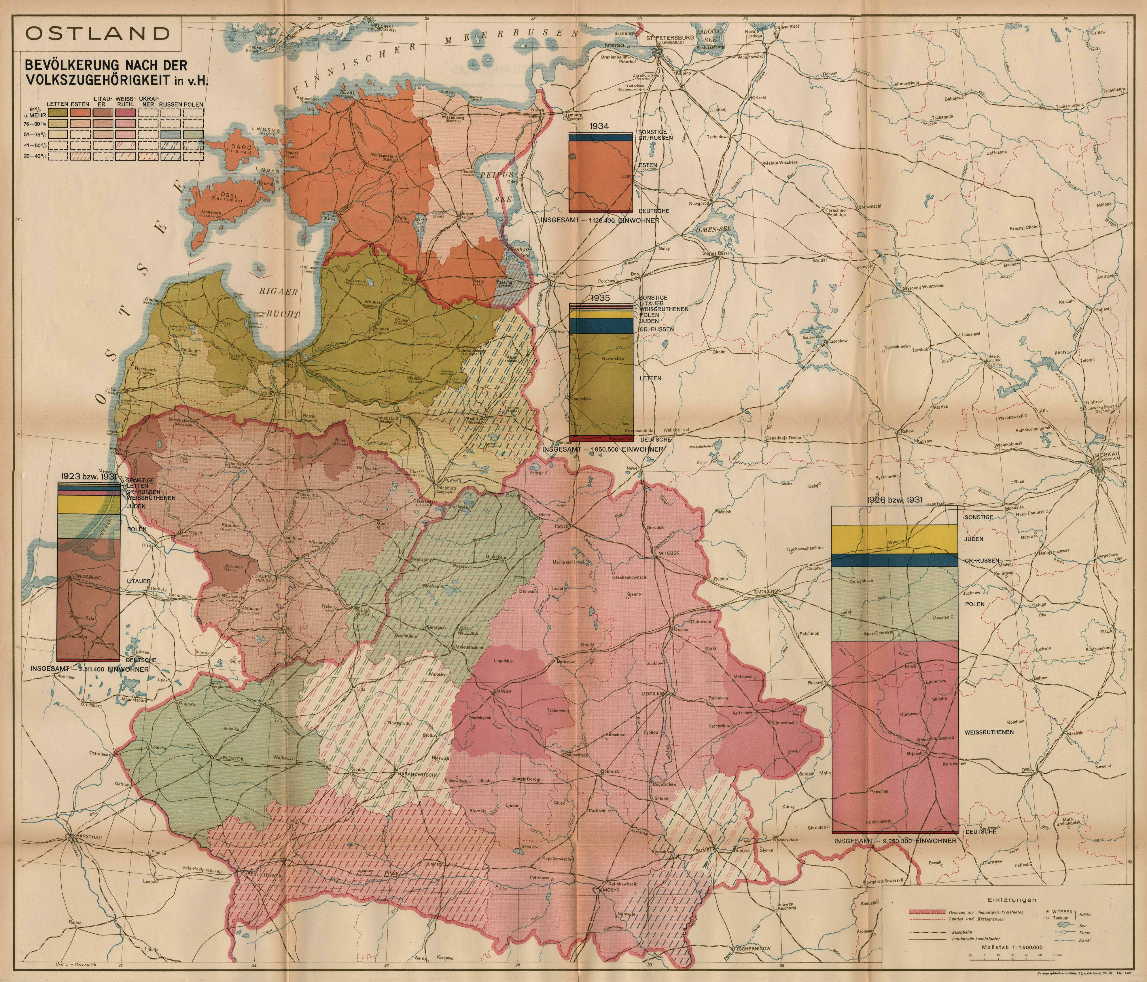


Bookmarks