

3


| Thumbs Up |
| Received: 3,787 Given: 2,516 |
The world Record goes to LA RINCONADA in Perù with a population of 50,000 permanent residents and 5,130 m of Altitude
https://en.m.wikipedia.org/wiki/La_Rinconada,_Peru
La Rinconada is a town in the Peruvian Andes located near a gold mine. At 5,100 m above sea level, it is the highest permanent settlement in the world. Between 2001 and 2009, the population increased to 30,000 people from just a small gold prospector camp because the price of gold rose 235% in the same time.
The town is located in the Ananea District, San Antonio de Putina Province. It lies at a height of 5,130 m (16,830 feet) above sea level. It sits at the foot of La Bella Durmiente, "The Sleeping Beauty" glacier. Some successful miners in La Rinconada have homes in Juliaca which has municipal services and is at a lower altitude.
Located high in the Andes, La Rinconada has an alpine / tundra climate (ET, according to the Köppen climate classification), with no month having average temperatures even close to the 10°C threshold that would permit tree growth and a subtropical highland classification for the city. Far above the tree line, La Rinconada is unique in its high elevation and population, with the highest city of comparable population (Cerro de Pasco) being located over 700m closer to sea level.
Owing to the extreme elevation of the town, climatic conditions more closely resemble that of the west coast of Greenland than somewhere located only 14° from the equator. The town has rainy summers and dry winters with a large diurnal variation seeing cool to cold days and freezing night time temperatures throughout the year, with common snowfalls. The average annual temperature in La Rinconada is 1.2 °C and the average annual rainfall is 707 mm.
The economy is mainly based on the production of gold from nearby gold mines, many artisanal.
Many miners work at the gold mine owned by Corporación Ananea. Under the cachorreo system they work for 30 days without payment. On the 31st day they are allowed to take with them as much ore as they can carry on their shoulders. Whether the ore contains any gold or not is a matter of luck. Pocketing of nuggets or promising chunks of rich ore is tolerated. Women are banned from the mines, but pallaqueras can be seen working though rock on the mine dumps.
Inca Manco Cápac International Airport is the nearest commercial airport; it is located in Juliaca.
The town lacks plumbing and sanitation systems. There is also significant contamination by mercury,[citation needed] due to the mining practices. Local miners refine the ore by grinding and treating it with mercury and pressing the mass through a cloth to filter it. The resulting amalgam is heated, to remove the mercury.
Last edited by GiCa; 09-01-2018 at 01:14 PM.
| Thumbs Up |
| Received: 3,787 Given: 2,516 |
EL ALTO in Bolivia is instead the highest city with more than 100,000 permanent inhabitants in the world
Population: 842,378
Altitude: 4,150 m
https://en.m.wikipedia.org/wiki/El_Alto
El Alto (Spanish for "The Heights") is a municipality and the second-largest city in Bolivia, located adjacent to La Paz in Pedro Domingo Murillo Province on the Altiplano highlands. El Alto is today one of Bolivia's fastest-growing urban centers, with a population of 974,754 in 2011. El Alto is the highest major metropolis in the world, with an average elevation of 4,150 m (13,615 ft).
The El Alto-La Paz metropolitan area, formed by the cities of El Alto, La Paz, and Viacha, constitutes the most populous urban area of Bolivia, with a population of 2.3 million inhabitants (greater than the metropolitan area of the country's largest city of Santa Cruz de la Sierra).
The dry and inclement plain above La Paz was uninhabited until 1903 when the newly built railways from Lake Titicaca and Arica reached the rim of the canyon, where the La Paz terminus, railyards and depots were built along with a settlement of railway workers (a spur line down into the canyon opened in 1905). In 1925, the airfield was built as base for the new air force, which attracted additional settlement. In 1939, El Alto's first elementary school opened. El Alto started to grow tremendously in the 1950s when the settlement was connected to La Paz's water supply (before this, all water had to be transported from La Paz in tanker vehicles) and building land in the canyon became more and more scarce and expensive. In an administrative reform in March 1985, the district of El Alto and surroundings was politically separated from the City of La Paz (this date is officially referred to and celebrated as the city's "founding day"). In 1987, El Alto was formally incorporated as a city. In 1994, the city became the seat of the Roman Catholic Diocese of El Alto.
El Alto, known for its teeming streets and traffic, broke gender barriers by hiring "cholitas" in December 2013. These Aymara women dress in traditional, multi-layered Andean skirts and brightly embroidered vests, and work as traffic cops to bring order to its road chaos. In recent years, Bolivia’s cholitas have been breaking social barriers, conducting television programs, working in offices, holding public posts, and participating in native fashion shows and beauty contests.
El Alto can also mean "The Halt" in Spanish, and a story persists[citation needed] that the conquistador Alonso de Mendoza stopped in El Alto on 23 October 1548 on his way to founding the city of La Paz.
El Alto is the largest city in Latin America with a mostly Amerindian population. About 76% of its inhabitants are Aymara, 9% are Quechua, 15% are Mestizo (descendants of Amerindian and White Europeans), and less than 0.1% are Criollos (White). El Alto was once known as La Paz's bedroom community, though recent growth of commerce and industry has led some local authorities to claim the title of "Bolivia's Economic Capital." With this industrial growth, there is concern about water pollution by businesses, including tanneries and slaughterhouse, for the city and communities downstream. Rapid population growth means the city struggles to bring potable water and sewer service to parts of the population, especially on the fringes of the expanding urban area. Much of the cities roads are unpaved and most citizens do not have access to running water, sewerage, electricity or garbage collection for their homes.
The city contains La Paz’s El Alto International Airport. El Alto is one of the highest major cities in the world, up to 4,150 meters (13,615 feet) above mean sea level. It has a cold climate, with the highest average monthly maximum temperature being 17 °C (63 °F) in November. It is one of the fastest-growing cities in Bolivia, due to a trend in migration from Bolivia’s rural areas to the La Paz region that started with the rural reform of 1952 and increased in the last 10 years. Some migrants say the difficulty of growing crops in the countryside drove them to move to the city.
The Köppen-Geiger climate classification system classifies El Alto's climate as a rare cool summer variety of a subtropical highland climate (Cwc).
Museo de Arte Antonio Paredes Candia opened in 2002. From 2003, access from La Paz to the international airport, as well to oil and gas supplies, has been frequently blocked by protesting social leaders and some of the most powerful players in the politics of Bolivia. El Alto remains one of the major centers of the Bolivian gas conflict.
There is a large open-air market.
Last edited by GiCa; 09-01-2018 at 01:13 PM.
| Thumbs Up |
| Received: 3,787 Given: 2,516 |
World top highest
Towns: more than 50,000 less than 100,000 inhabitants
LA RINCONADA, ananea distr., san antonio de putina prov., puno region, peru 5,130 m
CERRO DE PASCO, pasco prov., pasco region, perù 4,330 m
TULCAN, carchi, Ecuador 2,980 m
ANDAHUAYLAS, andahuaylas prov., apurimac region, perù 2,926 m
Cities with more than 100,000 inhabitants
EL ALTO, pedro domingo murillo prov., la paz dep., bolivia 4,150 m
POTOSÍ, tomas frias prov., potosi dep., bolivia 4,090 m
SAMZHUBZÊ district, Tibet, china 3,836 m
JULIACA, juliaca distr., san roman prov., puno region, perù 3,824 m
PUNO, puno prov., puno region, perù 3,819 m
ORURO, cercado prov., oruro dep., bolivia 3,709 m
LHASA, Tibet, china 3,656 m
LA PAZ, pedro domingo murillo prov., la paz dep., bolivia 3,640 m
CUSCO, cusco prov., cusco region, perù 3,399 m
HUANCAYO, huancayo prov., junin region, perù 3,259 m
HUARAZ, huaraz prov., ancash region, perù 3,052 m
IPIALES, nariño, Colombia 2,898 m
QUITO, pichincha, Ecuador 2,850 m
GOLMUD, haixi, Qinghai, china 2,809 m
TUNJA, boyacá, Colombia 2,782 m
AYACUCHO, huamanga prov., ayacucho region, perù 2,761 m
RIOBAMBA, chimborazo, Ecuador 2,754 m
CAJAMARCA, cajamarca region, perù 2,750 m
LATACUNGA, Cotopaxi, Ecuador 2,750 m
SUCRE, oropeza prov., chuquisaca dep., bolivia 2,750 m
TOLUCA DE LERDO, Toluca, Mexico 2,663 m
BOGOTÁ, Colombia 2,640 m
METEPEC, state of Mexico, Mexico 2,610 m
DUITAMA, tundama prov., boyacá dep., Colombia 2,590 m
AMBATO, tungurahua prov., Ecuador 2,577 m
COCHABAMBA, cercado prov., cochabamba dep., bolivia 2,574 m
SOGAMOSO, sugamuxi prov., boyacá dep., Colombia 2,569 m
SOACHA, soacha prov., cundinamarca dep., Colombia 2,565 m
KANGDING, garzê Tibetan pref., Sichuan, china 2,560 m
CUENCA, Cuenca canton, azuay prov., Ecuador 2,550 m
PASTO, nariño, Colombia 2,527 m
ADDIS ABABA, Ethiopia 2,500 m
LERMA, state of Mexico, Mexico 2,500 m
Last edited by GiCa; 09-02-2018 at 05:36 PM.
| Thumbs Up |
| Received: 3,787 Given: 2,516 |
Highest in europe over 100,000 inhabitants
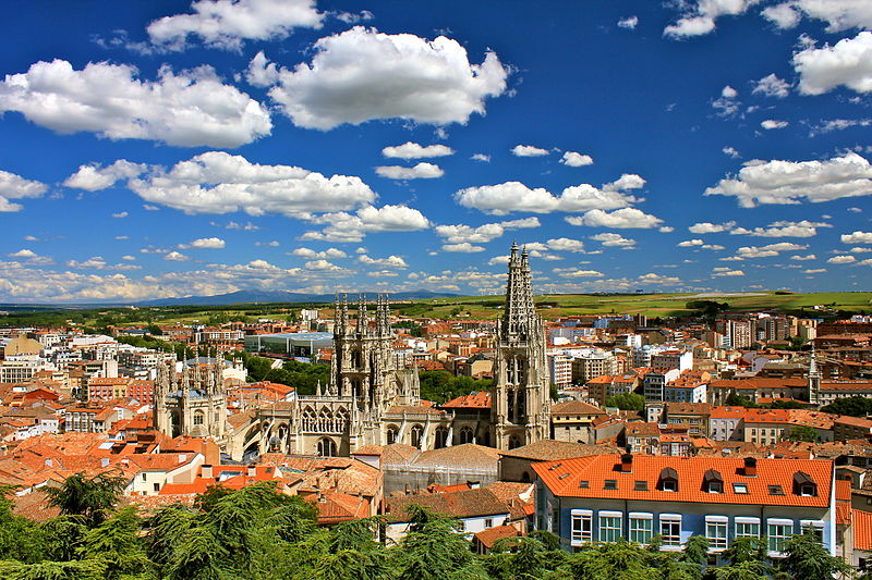
BURGOS, Castille and Leon, Spain 859 m
https://en.m.wikipedia.org/wiki/Burgos
Burgos (Spanish pronunciation: [ˈbuɾɣos], UK: /ˈbʊərɡɒs/, US: /ˈbʊərɡoʊs/) is a city in northern Spain and the historic capital of Castile. It is situated on the confluence of the Arlanzón river tributaries, at the edge of the Iberian central plateau. It has about 180,000 inhabitants in the actual city and another 20,000 in the metropolitan area. It is the capital of the province of Burgos, in the autonomous community of Castile and León. Burgos was once the capital of the Crown of Castile, and the Burgos Laws or Leyes de Burgos which first governed the behaviour of Spaniards towards the natives of the Americas were promulgated here in 1512.
It has many historic landmarks, of particular importance; the Cathedral of Burgos (declared World Heritage Site by UNESCO in 1984), seat of the Metropolitan Roman Catholic Archdiocese of Burgos, the Las Huelgas Reales Monastery and Miraflores Charterhouse. A large number of churches, palaces and other buildings from the medieval age remain. The city is surrounded by the Fuentes Blancas and the Paseo de la Isla parks.
Castilian nobleman, military leader and diplomat El Cid Campeador is a significant historical figure in the city, as he was born a couple of kilometres north of Burgos and was raised and educated here.
The city forms the principal crossroad of northern Spain along the Camino de Santiago, which runs parallel to the River Arlanzón.
It has a well-developed transportation system, forming the main communication node in northern Spain. In 2008, the international Burgos Airport started to offer commercial flights. Furthermore, AVE high speed trains are planned to start service in the near future, stopping at the newly-built Rosa de Lima train station.
The Museum of Human Evolution was opened in 2010, unique in its kind across the world and projected to become one of the top 10 most-visited museums in Spain. The museum features the first Europeans, which lived in this area 800,000 years ago.
Burgos was selected as the Spanish Gastronomy Capital of 2013.
At an elevation of 856 metres (2,808 ft), the city of Burgos lies in the transition zone between a Warm-summer Mediterranean climate (Köppen Csb) and an Oceanic climate (Köppen Cfb), with some continental influence resulting from its distance from the sea and higher altitude. Burgos' climate features chilly and windy winters, due to altitude and an inland location, which always include snow and temperatures below freezing. Temperature ranges can be extreme and Burgos is drier than Spain's coastal regions, although there is year-round precipitation. Average annual precipitation is 546 mm (21.5 in) and the average annual relative humidity is 72%. In winter, temperatures very often (almost every day) drop below freezing, often reaching temperatures as low as −10 °C (14 °F), and snowfalls are common, while the summer months see average high temperatures of 27.5 °C (81.5 °F).
Last edited by GiCa; 09-01-2018 at 04:24 PM.
| Thumbs Up |
| Received: 3,787 Given: 2,516 |
Highest in europe over 50,000 inhabitants
AVILA, Castile and León, Spain 1,132 m
https://en.m.wikipedia.org/wiki/Ávila,_Spain
Ávila (Spanish pronunciation: [ˈaβila]; Latin: Abula) is a Spanish town located in the autonomous community of Castile and León, and is the capital of the Province of Ávila.
It is sometimes called the Town of Stones and Saints, and it claims that it is one of the towns with the highest number of Romanesque and Gothic churches per capita in Spain. It has complete and prominent medieval town walls, built in the Romanesque style. The town is also known as Ávila de los Caballeros, Ávila del Rey and Ávila de los Leales (Ávila of the Knights, the King and the Loyalists), each of these epithets being present in the town standard.
Orson Welles once named Ávila as the place in which he would most desire to live, calling it a "strange, tragic place", while writer José Martínez Ruiz, in his book El alma castellana (The Castilian Soul), described it as "perhaps the most 16th-century town in Spain".
It was declared a UNESCO World Heritage Site in 1985.
Ávila's position results in a temperate Mediterranean climate (Csb, according to the Köppen climate classification), with warm summers and chilly winters with snowfalls, bordering on a cold semi-arid climate (BSk). The hottest month, July, has an average temperature of 20.6 °C (69 °F), and the coldest month, January, has an average of 3.0 °C (37 °F). The average annual precipitation is 416 mm (16.38 in).[3] Annual rainfall is low compared to surrounding areas, implying that it lies in a rain shadow. The Adaja is dry for several months of the year and the town has historically had water supply problems. Ávila is the provincial capital city in Spain with the coldest winter low temperatures, which is caused for its altitude, as the city has an average elevation of 1,132 metres (3,714 ft) above sea level.
| Thumbs Up |
| Received: 3,787 Given: 2,516 |
Highest in europe over 10,000 inhabitants
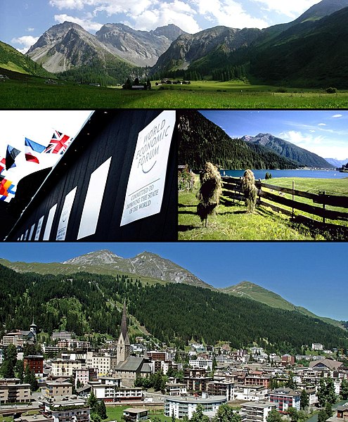
DAVOS, Prättigau/Davos district, Graübunden, Switzerland 1,560 m
https://en.m.wikipedia.org/wiki/Davos
Davos (German pronunciation [daˈfoːs] or [daˈvoːs]; Romansh: About this sound Tavau (help·info), archaic Italian: Tavate) is an Alpine town, and a municipality in the Prättigau/Davos Region in the canton of Graubünden, Switzerland. It has a permanent population of 11,060 (2016). Davos is located on the river Landwasser, in the Rhaetian Alps, between the Plessur and Albula Range. At 1,560 m (5,120 ft), it is described as "the highest town in the Alps".
The former Alpine resort village consists of two parts: Davos Dorf (lit.: "village") to the northeast towards Klosters and further down through the Prättigau to Landquart, and Davos Platz (lit.: "place") to the southwest, which opens into the valley of the Landwasser (lit.: "country water") and eventually leads to Filisur. During summer season the Flüela Pass leads south-east into the Lower Engadine.
Davos is host to the World Economic Forum (WEF), an annual meeting of global political and business elites (often referred to simply as Davos) and the home of one of Switzerland's biggest ski resorts. At the end of every year it serves as the site of the annual Spengler Cup ice hockey tournament, hosted by the HC Davos local hockey team.
Davos has a subarctic climate (Köppen Dfc) with an average of 124.7 days of precipitation per year and on average receives 1,022 mm (40.2 in) of precipitation.
The wettest month is August during which time Davos receives an average of 148 mm (5.8 in) of precipitation. During this month there is precipitation for an average of 13.5 days. The month with the most days of precipitation is June, with an average of 13.6, but with only 126 mm (5.0 in) of precipitation. The driest month of the year is April with an average of 56 mm (2.2 in) of precipitation over 9.6 days, of which 50.9 cm (20.0 in) in 8.5 days are snowfall.
Last edited by GiCa; 09-01-2018 at 04:42 PM.
| Thumbs Up |
| Received: 3,787 Given: 2,516 |
Highest elevation in europe for cities over 100,000 inhabitants
BURGOS, Castile and León, Spain 859 m
LEON, Castile and León, Spain 837 m
SALAMANCA, Castile and León, Spain 802 m
Highest Elevation in europe for cities over 50,000 inhabitants
AVILA, Castile and León, Spain 1,132 m
SEGOVIA, Castile and León, Spain 1,002 m
Highest elevation in europe for cities over 10,000 inhabitants
DAVOS, Prättigau/Davos, Graübunden, Switzerland 1,560 m
BRIANÇON, Haute Alps, Provence Alps Cote d'Azur, France 1,326 m
SORIA, Castile and León, Spain 1,063 m
GUARDA, Beira Interior Norte, Centro, Portugal 1,056 m
SAN GIOVANNI IN FIORE, Cosenza, Calabria, Italy 1,050 m
SMOLYAN, Bulgaria 1,050 m
ANDORRA LA VELLA, Andorra 1,023 m
SJENICA, Zlatibor, Serbia 1,010 m
LA CHAUX De FONDS, Neuchatel, Switzerland 1,001 m
Last edited by GiCa; 09-01-2018 at 05:09 PM.


| Thumbs Up |
| Received: 10,627 Given: 10,176 |
But the question here is, does altitude influence phenotype or is it just a matter of parallels? Does the third dimension matter?
Giiicoo
| Thumbs Up |
| Received: 3,787 Given: 2,516 |
More Altitude more convex nosesOriginally Posted by Faklon

At least it's very true for peruvians
And maybe a stockier torso
And yes... For sure darker skin as sun radiation is higher in elevated altitude
| Thumbs Up |
| Received: 10,627 Given: 10,176 |
And what if this is because we observe them from downwards?
There are currently 1 users browsing this thread. (0 members and 1 guests)
 Italia
 Posting Permissions


 Reply With Quote


Bookmarks