

1


| Thumbs Up |
| Received: 19,712 Given: 5,851 |
Europa Regina
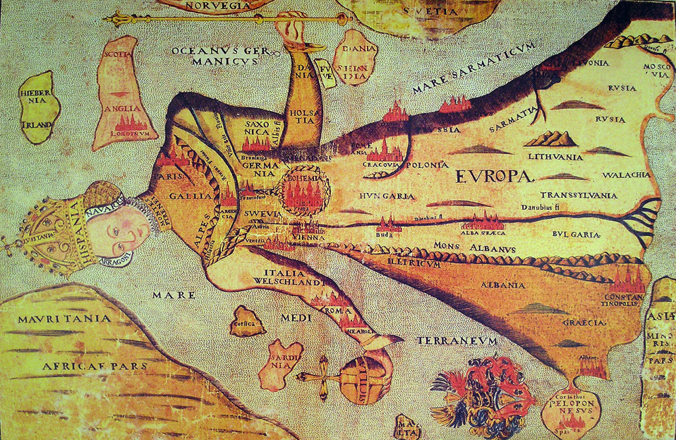
Old map of Northern Europe.

| Thumbs Up |
| Received: 19,712 Given: 5,851 |
I like how the grand Orcades/Orkney is of similar size to feeble Scotland.For a while a part of Norway.


| Thumbs Up |
| Received: 2,779 Given: 1,359 |
Do you know how old is this map ??Originally Posted by Graham


| Thumbs Up |
| Received: 20,617 Given: 48,345 |
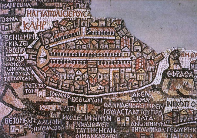
Some late medieval map, with Jerusalem in the centre of the world.

| Thumbs Up |
| Received: 19,712 Given: 5,851 |
16th century..
There was a few of this fashion. Here's another from 1587. In more detail, you'll have to zoom in.


| Thumbs Up |
| Received: 3,665 Given: 619 |
When I was a kid, my father brought home from I know not where an enormous collection of National Geographic magazines spanning the years 1917 to 1985. I found, tucked in almost every issue, one of the magazines gorgeous mapsof the Moon, St. Petersburg, the Himalayas, Eastern Europes ever-shifting boundaries. I became a cartography enthusiast and geographical sponge, poring over them for years just for the sheer enjoyment of it, a pleasure that remains with me today. Whether youre like me and simply love the imaginative exercise of tracing a maps lines and contours and absorbing information, or you love to do that and you get paid for it, youll find innumerable ways to spend your time on the new Open Access Maps project at the New York Public Library. The NYPL announces the release with the explanation below:
The Lionel Pincus & Princess Firyal Map Division is very proud to announce the release of more than 20,000 cartographic works as high resolution downloads. We believe these maps have no known US copyright restrictions.* To the extent that some jurisdictions grant NYPL an additional copyright in the digital reproductions of these maps, NYPL is distributing these images under a Creative Commons CC0 1.0 Universal Public Domain Dedication. The maps can be viewed through the New York Public Librarys Digital Collections page, and downloaded (!), through the Map Warper.
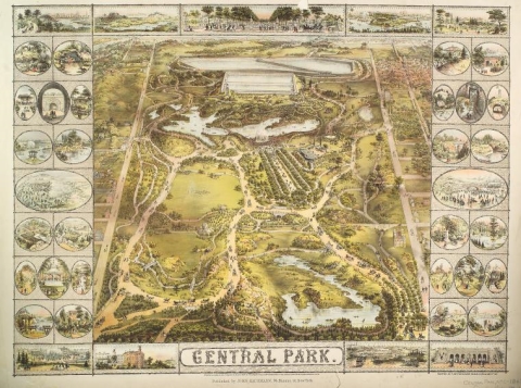
What does this mean? Simply put, it means you can have the maps, all of them if you want, for free, in high resolution. Maps like that above, of New Yorks Central Park, issued in 1863, ten years before Frederick Law Olmstead and Calvert Vaux completed their historic re-design.
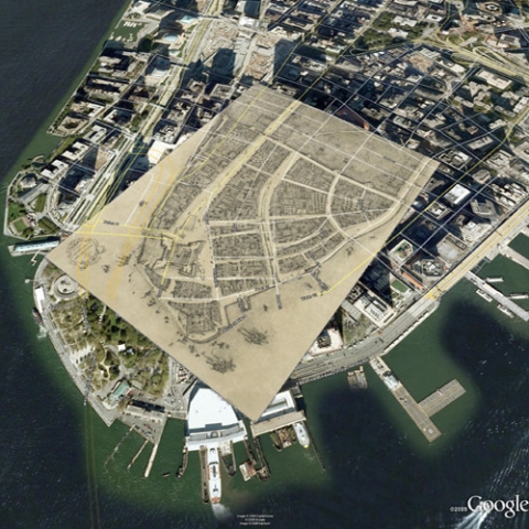
Can youas I did with my neatly folded, yellowing archivehave all the maps in full-color print? Well, no, unless youre prepared to bear the cost in ink and paper and have some specialized printing equipment that can render each map in its original dimensions. But you can access something worlds away from what I could have imagineda digital enhancement technology called warping, also known as georectification. This, explains the NYPL, is the process where digital images of maps are stretched, placing the maps themselves into their geographic context, rendered either on the website or with tools such as Google Earth. For example, below see a warping of the 1916 Redraft of the 1660 Castello Plan for then-New Amsterdam over a current-day Google Earth image of lower Manhattan (and note how much the island has been expanded past its 17th century shores). The warping technology is open access, meaning that anybody with a computer can create an account, log in, and begin warping and tracing maps. User contributions remain, a la Wikipedia, and add one more piece to this new historical geographic data model.
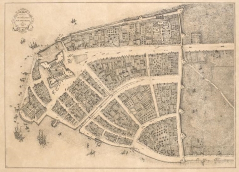
The warper is a special feature that helps place historical maps in a modern visual field, but it in no way ruins the enjoyment of those maps as archival pieces or art objects. You can see cartographer John Wolcott Adams original 1916 Castello Plan redraft below, and visit NYPLs Digital Collections for a high resolution image, fully zoomable and, yes, printable.
For more on the incredible warping technology NYPL makes available to us, see this extended blog post, Unbinding the Atlas: Working with Digital Maps. Over ten thousand of the collections maps are of New York and New Jersey, dating from 1852 to 1922, including property, zoning, and topographic maps. In addition, over one thousand of the maps depict Mid-Atlantic cities from the 16th to the 19th centuries, and over 700 are topographic maps of the Austro-Hungarian Empire between 1877 and 1914. That should be enough to keep any amateur or professional map-lover busy for a good long while. Start digging into the maps here.
Related Content:
The British Library Puts 1,000,000 Images into the Public Domain, Making Them Free to Reuse & Remix
Download 15,000+ Free Golden Age Comics from the Digital Comic Museum
Download Over 250 Free Art Books From the Getty Museum
14,000 Free Images from the French Revolution Now Available Online
New York Public Library Puts 20,000 Hi-Res Maps Online & Makes Them Free to Download and Use - Open Culture


| Thumbs Up |
| Received: 11 Given: 9 |
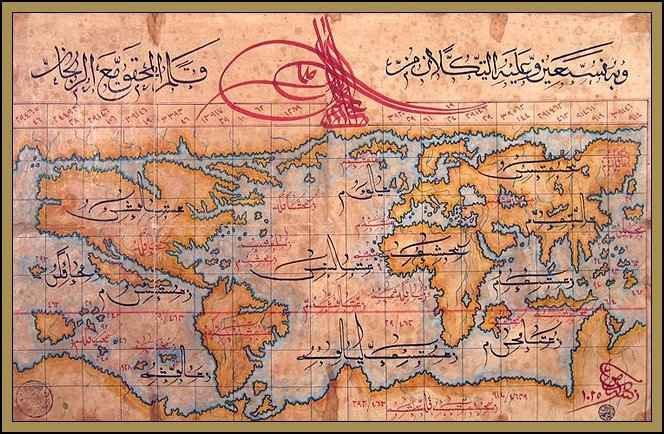
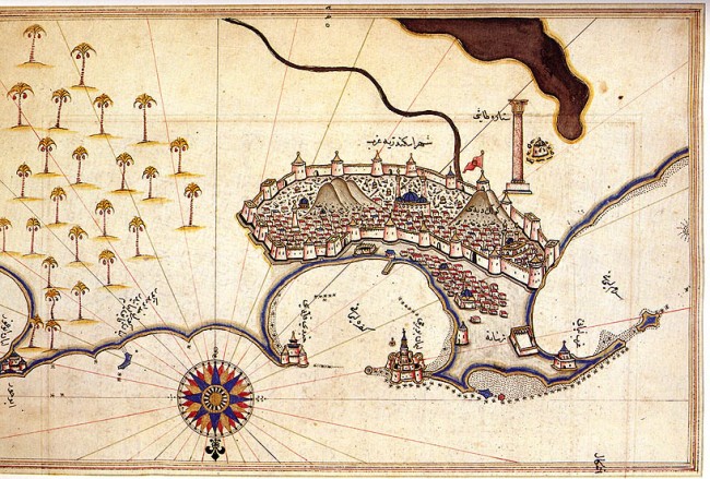
here is the turkish " world map" from 1512


| Thumbs Up |
| Received: 35,744 Given: 17,041 |
Ten Beautiful Medieval Maps
Our list of the best medieval maps ten maps created between the sixth and sixteenth centuries, which offer unique views into how medieval people saw their world. These maps are arranged chronologically, which helps to reveal some of the changes that took place during the Middle Ages in how people created maps.
Madaba Mosaic Map
In 542 AD, a Byzantine church was built at Madaba, Jordan. When it was built, or in the first thirty years after, a large mosaic was laid which depicted the Holy Land with Jerusalem. An earthquake struck Madaba in 746 and the town was abandoned. It was not until 1884 the mosaic was rediscovered.
Only part of the mosaic survives, but it reveals much about the Holy Land. Jerusalem, in particular, is finely detailed, showing streets and buildings.
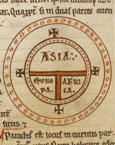
The T-O Map of Isidore of Seville
Isidore of Seville (c. 560 636) was one of the leading scholars of the Early Middle Ages. Near the end of his life he wrote Etymologiae, a kind of encyclopedia of world knowledge that filled 20 volumes. Among the pages of this work is a map of the world he created. Isidore describes the world this way:
The mass of solid land is called round after the roundness of a circle, because it is like a wheel [...] Because of this, the Ocean flowing around it is contained in a circular limit, and it is divided in three parts, one part being called Asia, the second Europe, and the third Africa.
This type of map, which historians refer to as a T-O map, became the basis for many medieval maps.
The Mappa Mundi of Saint Beatus of Liébana (c.730 c.800)
Beatus of Liébana was a monk geographer from the Iberian Kingdom of Asturias during the eighth-century. He created this world map around the year 776, basing it on the accounts given by Isidore of Seville, Ptolemy and the Holy Bible.
The original version of this map does not survive, but several copies were made, including the one shown here, which comes from the monastery of St.Sever in France. Some interesting details including placing the Garden of Eden at the end of Asia and locating a fourth continent beyond Africa.
Tabula Rogeriana
Muhammad al-Idrisi (10991165 or 1166) was born in the north African town of Ceuta but spent much of his early life traveling around the known world, going as far as York in England, Hungary and Anatolia. He settled on the island of Sicily and began working for the Norman King Roger II. In 1154 he created for him the Tabula Rogeriana, which offers a description of the world and over 70 maps of various places. The centre-piece of this book is his world map, which depicts Europe, Asia and the northern part of Africa (the southern part of the world is at the top of the map). Al-Idrisi states that it shows the seven climatic regions, with their respective countries and districts, coasts and lands, gulfs and seas, watercourses and river mouths.
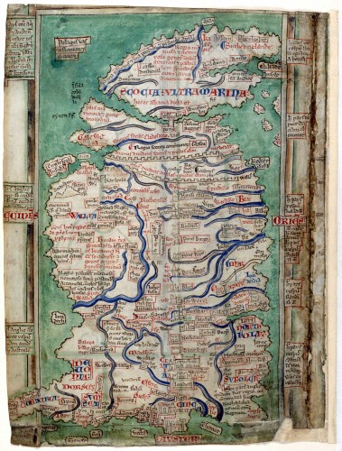
Matthew Paris Map of Britain
Matthew Paris (c. 1200 1259) is one of the most well-known people from 13th century England. This Benedictine monk wrote many works and illustrated them himself. He also created several maps, including this one of Britain which he drew around 1250. This map features over 250 place names and includes such features as Hadrians Wall and Mount Snowdon in Wales. You can read more about this map from the British Library.
Hereford Mappa Mundi
Created around 1290, this large map of the world is another version of the T-O map but much more detailed. Owned by Hereford Cathedral for hundreds of years, they almost sold it off in the 1980s, but a public outcry led to a £3 million donation which created a new home for the map in Hereford.
In his book On the Map: A Mind-Expanding Exploration of the Way the World Looks, Simon Garfield gives his own own vivid description of the Hereford Mappa Mundi: The map is frantic alive with activity and achievement. Once you grow accustomed to it, it is hard to pull yourself away. There are approximately eleven hundred place-names, figurative drawings and inscriptions, sourced from biblical, classical and Christian texts In its distillation of geographical, historical and religious knowledge the mappa serves as a itinerary, a gazatteer, a parable, a bestiary and an educational aid. Indeed, all history is here, happening at the same time: the Tower of Babel; Noahs Ark as it comes to rest on dry land; the Golden Fleece; the Labyrinth in Crte where the Minotaur loved. And surely for contemporaries locals and pilgrims it must have constituted the most arresting freak show in town. With its parade of dung-firing animals, dog-headed or bat-eared humans, a winged sphinx with a young womans face, it seems closer to Hieronymus Bosch than to the scientific Greek cartographers.
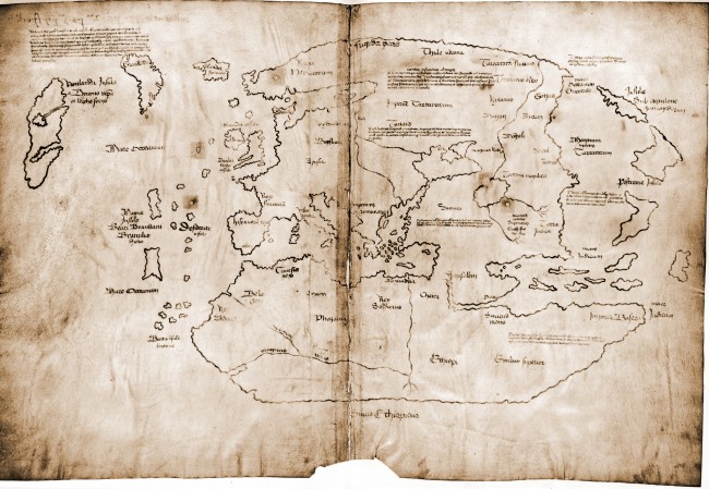
The Vinland Map
Scholars are not sure if this is genuine map from the 15th century, as it was only revealed to the public in 1965 under somewhat suspicious circumstances. But if the map is real, it is the earliest depiction of North America, revealing new details about the Norse settlement of Vinland.
The Maps of Piri Reis
The Ottoman Admiral Piri Reis (ca. 1470 1553/4) compiled his Book on Navigation in 1521 it contains detailed information on navigation, and includes accurate charts and maps of Europe and the Mediterranean area. He included maps of ports such as Istanbul, Venice and Alexandria (which is displayed above). He also produced two maps of the world, the first in 1513 and the second in 1529.
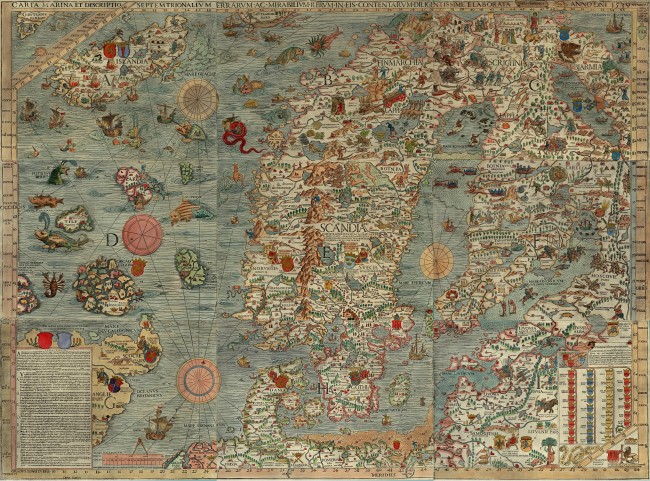
Carta Marina
This map was first printed in Venice in 1539 it was created by the Olaus Magnus, a Swedish ecclesiastical official who lived in Italy from 1524 to his death in 1567. This map of Scandinavia is very large (125 cm tall and 170 cm wide) and is colourfully illustrated with various animals and monsters.
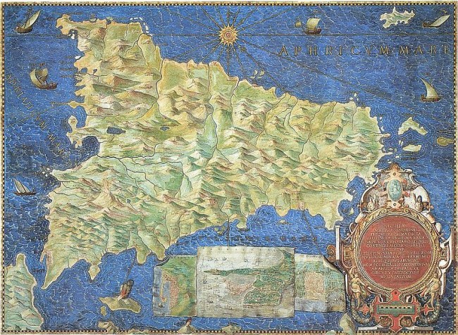
The Gallery of Maps
When visiting the Vatican Museum, one will enter a long hallway known as The Gallery of Maps. The gallery was commissioned in 1580 by Pope Gregory XIII, with the 40 panels created by Ignazio Danti. They depict Italy and its various regions, including this map of Sicily.
Source: http://www.medievalists.net/2013/07/...medieval-maps/
| Thumbs Up |
| Received: 35,744 Given: 17,041 |
The Atlas Blaeu-Van der Hem
his documentary takes a look at the Atlas Blaeu-Van der Hem one of the largest and greatest atlases ever assembled. Created by Willem Blaeu and his son Joan in 17th century Amsterdam, the atlas contains nearly 600 maps charting the world. It was published in different languages Latin, German, French, Spanish and Dutch.
This documentary also shows how publishers created a facsimile of the historical eight-volume Atlas in the Austrian National Library.
Here are some images created by the Willem and Joan Blaeu:
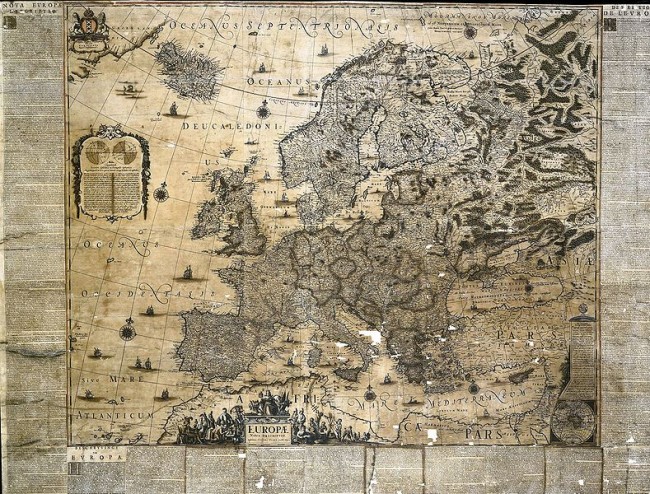
Map of Europe created by Joan in 1659
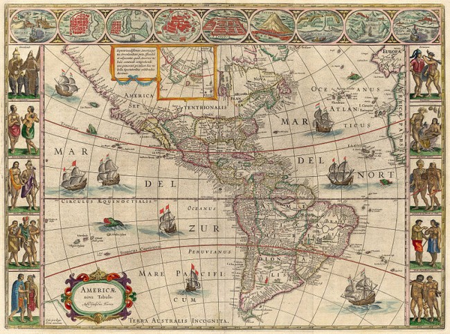
Map of the Americas from 1621
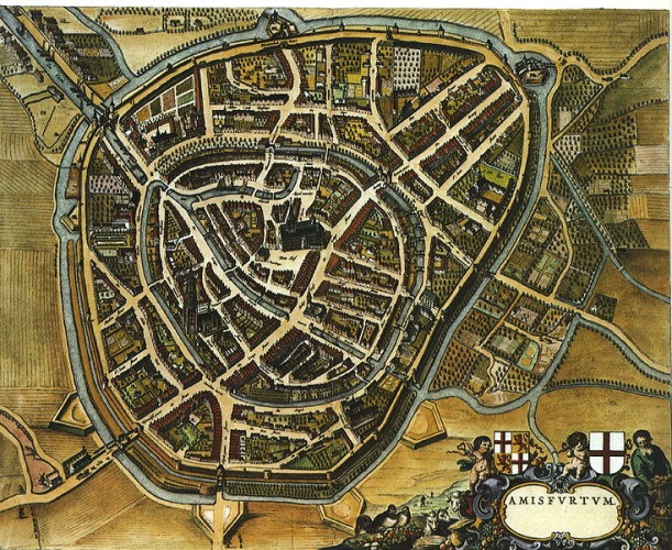
City of Amersfoort in the Netherlands, from 1652
Detail of a Palace in Liege
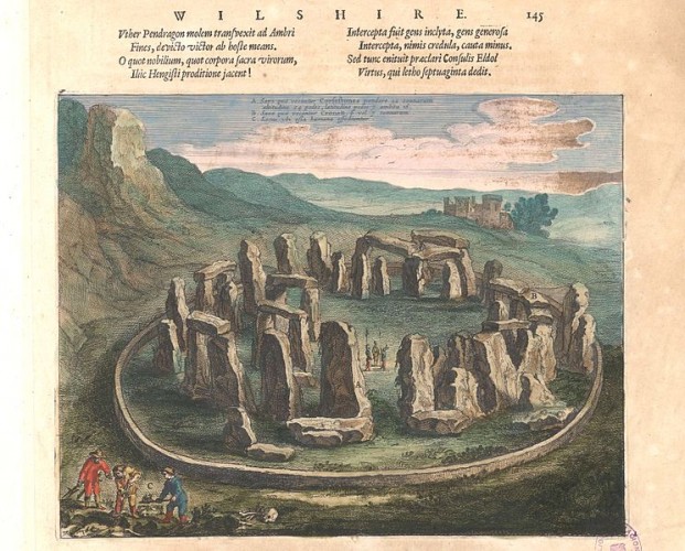
View of Stonehenge created by Joan Blaeu in 1645
Source: http://www.medievalists.net/2014/03/...u-van-der-hem/
There are currently 1 users browsing this thread. (0 members and 1 guests)
 България
 Posting Permissions

 Reply With Quote


Bookmarks