

2


| Thumbs Up |
| Received: 35,740 Given: 17,041 |
500 year old map of America discovered in Munich
A previously unknown version of Martin Waldseemüllers famous world map has been disocvered in the collections of the University Library in Munich. On this map, the New World appears for the first time under the name America, chosen to honor the explorer Amerigo Vespucci (1451 1512), whom Waldseemüller erroneously regarded as the discoverer of the continent.
Detailed version: http://epub.ub.uni-muenchen.de/13138/1/Cim._107-2.pdf
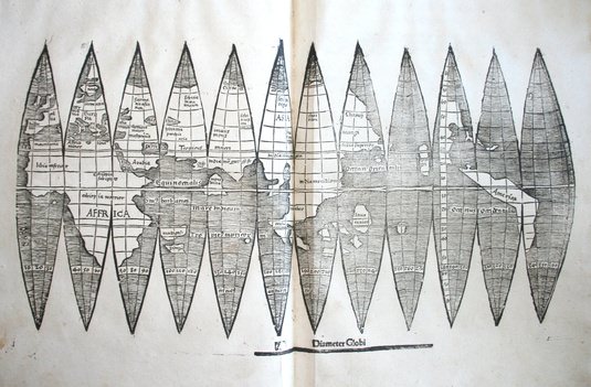
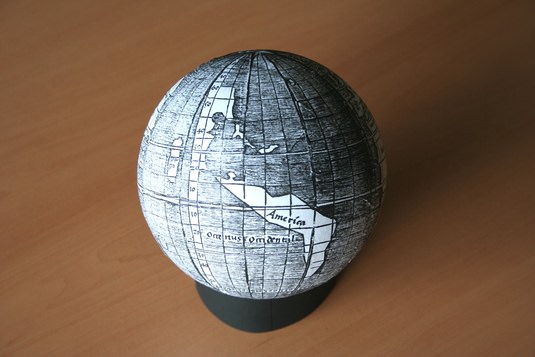
Waldseemüller and his colleague Matthias Ringmann created the map in their workshop in the monastery of Saint-Dié-des-Vosges around the year 1507. Four other versions of the map are known to exist, and one of them was sold at auction in 2005 for $1 million. This fifth version is created in so-called globe segments, which depict the world in twelve individual segments, or rather surface wedges, which taper to a point at each end and are printed on a single sheet, like cut-outs on construction paper. When correctly arranged, they form a small globe of about 11 cm in diameter. And in the three rightmost wedges, one sees a huge, boomerang-shaped landmass in the middle of an immense ocean. The globe places America in the remotest West, seen from Europe and Africa, on the far side of a wide, wide sea.
The newly discovered sheet differs in a number of details from the copies that were already known, and can therefore be regarded as unique, says Sven Kuttner, Curator of the Librarys Department of Early Printed Books. For one thing, the outlines of the upper halves of the lanceolate sections are much less distinctively incised. The position of Calicut on the Malabar Coast, where Vasco da Gama (1469 1523) had made landfall in May 1498, is shown on the fourth, not the fifth, segment of the global map. The style of hatching and the forms of certain letters also differ from their counterparts in other copies. Furthermore, according to Kuttner, the watermark impressed in the paper suggests that this version may have been printed at some time after the first edition of 1507, somewhere in Alsace.
The new Munich copy of the segmented map itself has obviously followed a tortuous course to reach its present haven. And the story of this voyage is at least as fascinating as that of the discovery and exploration of the New World. Its latest chapter began only a few days ago in the Munich University Library. While working on an ongoing revision of the catalogs, a bibliographer came across something quite sensational in an otherwise unremarkable volume that had been rebound in the 19th century. Tucked in between two printed works on geometry from the early 16th century was the unsought map a double-page spread in roughly A4 format. The three prints obviously date from the same period, but is there a direct connection between the not entirely disparate subjects? The 19th-century librarians, at any rate, had failed to recognize the significance of Waldseemüllers map, Kuttner remarks. The first copy of the segmental maps to be discovered only turned up in 1871, in the Hauslab-Liechtenstein Library in Vienna. And the Munich copy was returned to the obscurity of the stacks.
But it survived the Second World War unscathed, although the University Library itself was devastated by air raids. In November 1942, large portions of the holdings of older books, including the unassuming volume containing the two geometry treatises, had been transferred to a safer rural location. Stefan Kuttner has ascertained that the book was among the contents of deposit box No. 340, which was first stowed away in Burghausen, and later transported to Niederviehbach near Landshut. The box was returned to Munich in 1955, and provisionally stored in the Northeastern Repository at LMU.
Regrettably, according to Kuttner, the origins of this copy of the segmented world map remain mysterious. One of the works on geometry with which it was bound belonged to the Monastery Library in Oberalteich. The contents of that collection, some 1,400 volumes in all, came into the possession of the University Library, then located in Landshut, during the secularization phase after the break-up of the Holy Roman Empire in 1803.
On the other hand, the map could also be directly related to the copy of the Cosmographiae Introductio in the University Librarys own collection. This is a unique early edition with a two-page colored map of the world, sketched in a rather cursory fashion with pen and ink. It was originally part of the collection assembled by the Swiss humanist and polymath Heinrich Loriti Glareanus (1488 1563). The contents of Glareans library were acquired by Johann Egolph von Knöringen (1537 1575), a later Bishop of Augsburg, when he was still a student at Freiburg University. In 1573, he stipulated in his will that his books, more than ,6000 volumes in all, were to be donated as an endowment to the University Library of Ingolstadt, the forerunner of the Munich University Library.
Even in our digital age, the originals have lost none of their significance and unique fascination. Treasures like the newly discovered map can only be brought to light by people who work directly with originals, says Klaus-Rainer Brintzinger, the Director of the University Library, and adds: We intend to make the map accessible to the public in digital form in time for the Fourth of July Independence Day in the USA.
Source: http://www.medievalists.net/2012/07/...red-in-munich/


| Thumbs Up |
| Received: 1,160 Given: 893 |
| Thumbs Up |
| Received: 35,740 Given: 17,041 |
Back in the second century AD, the Roman geographer Claudius Ptolemy created his Cosmographia the precursor of the modern atlas. His work gave a description of the world, along with maps of various lands. During the Middle Ages, knowledge of Ptolemys work survived in the Middle East and Byzantium, and around the beginning of the fifteenth-century it was rediscovered by Western Europe. Medieval mapmakers soon started making use of this work, and created updated versions that incorporated the current geographical knowledge of the period.
One of these mapmakers was Nicolaus Germanus (c.1420-c.1490) a monk living at the Reichenbach Priory in Germany. Around the year 1467, he wrote a version of the Cosmographia that included maps of the known world, going from Greenland to India. Here are some of the images from that book:
The World
Italy
Rome
Sicily
England
Ireland
France
Greece
Jerusalem and the Holy Land
Egypt
Arabia
Greenland and Iceland
Source: http://www.medievalists.net/2014/07/29/world-1467/


| Thumbs Up |
| Received: 5,410 Given: 6,858 |


| Thumbs Up |
| Received: 4 Given: 1 |
Do you have historical maps of Asian Countries? Those might help with the territorial disputes between some Asian countries..


| Thumbs Up |
| Received: 2,035 Given: 1,241 |


| Thumbs Up |
| Received: 926 Given: 92 |
Karakalpakstan in the Ukraine (Chorni Klobuky)


| Thumbs Up |
| Received: 959 Given: 1,498 |
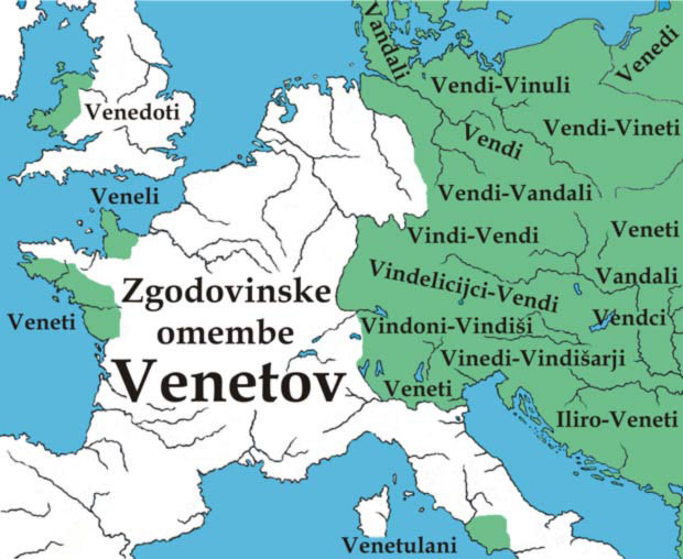
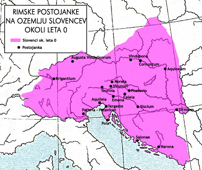
Slovenes before year 0.
Slovenes at year 0., fighting Julius Cezar
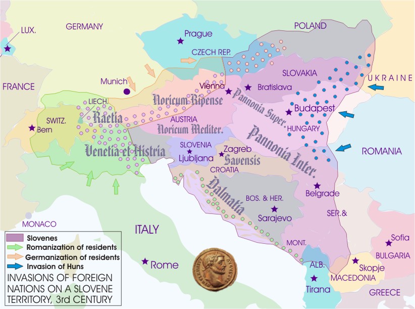
Slovenes, 3rd century
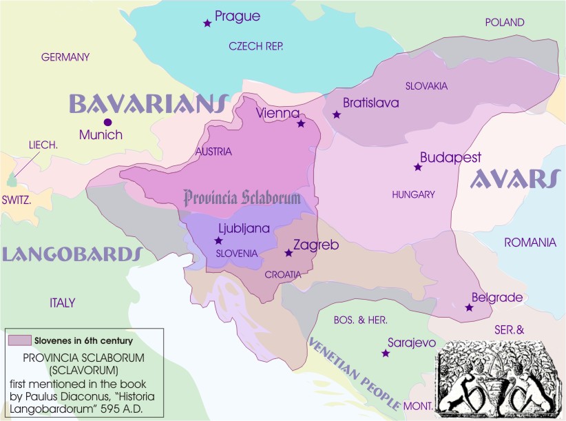
6th century
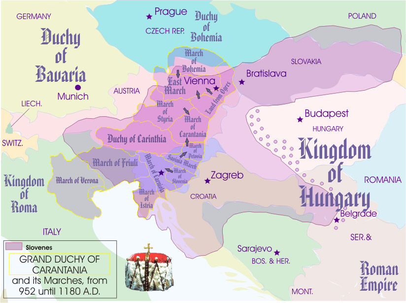
Principality of Carantania
| Thumbs Up |
| Received: 35,740 Given: 17,041 |
http://dailyinfographics.eu/world-war-ii-on-old-maps/
Europe few days before WW2
Invasion of Poland, 1939
The Conquest and Liberation of France
The Pacific Battlefield, Map published by TIME in 1941
Map of Auschwitz-Birkenau, biggest Nazi Death Camp
Map of Damage in Hiroshima
Dogs of War, British Propaganda Map
World War II Deaths (Dark Cross Soliders, White Cross Civilians, Star of David Jews)
Germany After War


| Thumbs Up |
| Received: 98 Given: 58 |
Spanish Empire
There are currently 3 users browsing this thread. (0 members and 3 guests)
 България
 Posting Permissions

 Reply With Quote


Bookmarks