


 United Kingdom
 Alba | Scotland
5


| Thumbs Up |
| Received: 19,706 Given: 5,850 |
Heart of Neolithic Orkney refers to a group of Neolithic monuments found on the Mainland, one of the islands of Orkney, Scotland. The name was adopted by UNESCO when it proclaimed these sites as a World Heritage Site in 1999.
The site of patrimony currently consists of four sites:
1. Maeshowe
2. Standing Stones of Stenness
3. Ring of Brodgar
4. Skara Brae
| Thumbs Up |
| Received: 19,706 Given: 5,850 |
Maes Howe is the finest chambered tomb in North West Europe and is older than the Egyptian pyramids. But what makes Maes Howe so special is the way this magnificent 5000 year old monument has been overlaid by another story written, literally, 4000 years later.
Maes Howe was probably built some time around 2800BC. It postdates Skara Brae by a few hundred years, and it has been speculated that it was the greater organisation needed to produce something as large as Maes Howe that led to the gradual decline of settlements like Skara Brae.
The building of Maes Howe was a vast undertaking. A circular platform 38m in diameter on a slight rise surrounded by heathland was cleared and levelled. The tomb was then built above ground, complete with its side chambers and entrance passage. Some of the slabs of rock used in the construction weigh up to 30 tonnes and some may have been dragged here for a considerable distance.
As the tomb was constructed it was buried in an artificial mound, itself containing structures and retaining walls to ensure stability. Much of the material for the mound probably came from the ditch that surrounds Maes Howe, which is 2m deep and 14m wide.
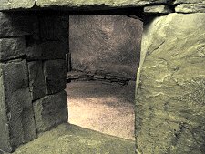
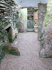
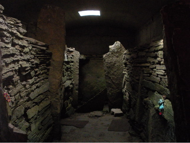
Maes Howe is entered through a low 9m long passage, with a large swivelling blocking stone still in place in its outer end. The passage climbs gently uphill (for drainage) and enters the main chamber, which is roughly square in shape and about 4.5m on each side. The sides are made up of gently corbelled flat blocks, fitted superbly closely together, with huge buttresses at each corner.
On three sides of the tomb there are side chambers. Each of these is roofed by a single huge slab, which is also keyed into and forms part of the wall of the main chamber. The workmanship is amazing. Overtopping everything is a white-painted stone cap that is probably lower than the original roof. This was placed here after the tomb had been excavated in 1861.
Although a great deal is known about the structure of Maes Howe, very little is really known about its purpose. It was presumably used to house the bones of the dead of the surrounding community, but only a trace of bone was found during the 1861 excavation.
The only thing that does seem certain is that the alignment of the tomb was used as a calendar. At sunset on midwinter's day the sun shines down the length of the entrance passage and illuminates an area low on the rear wall of the main chamber. It's been convincingly suggested that if you are living this far north, knowing exactly when the days are going to start getting longer again is a very important piece of information. It's easy to speculate that there were some wild midwinter parties held here 5000 years ago.
Towards 2000BC Maes Howe seems to have simply fallen into disuse. There is evidence that Orcadian society was going through a difficult period at the time. This was probably due to a deterioration of the climate and consequential southerly migration of most of the population. So for the next 3000 years Maes Howe was no more than a grassy mound in the Orkney landscape.
According to the Orkneyinga Saga, Earl Rognvald of Orkney led a crusade to the Holy Land in 1150. On 6 January 1153, Harald Maddadarson landed in Orkney from Argyll in an effort to take the islands in the absence of the Earl. He and his men broke into Maes Howe through the roof and spent some time sheltering there. Later in 1153 Earl Rognvald and his followers returned from their crusade, and they in turn explored the newly-opened tomb.
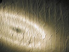
The evidence for this comes directly from the walls of the tomb, which carry many examples of graffiti left by the Vikings in the form of carved runes. These show just how little people have changed in the last thousand years. Many of the inscriptions are direct predecessors to today's graffiti. So you can find "Ottarfila carved these runes"; "Haermund Hardaxe carved these runes"; "Tholfr Klossienn's son carved these runes high up" (high on the wall near the roof); or the less modest "These runes were carved by the man most skilled in runes in the western ocean with this axe owned by Gauk Trandilsson in the South land".
Other inscriptions could be easily found today spray-painted in city underpasses the world over: "Thorni bedded, Helgi carved" on the wall of one of the side chambers: Thorni was a woman's name. Elsewhere, in the main chamber, is the relatively innocent "Ingigerth is the most beautiful of women". Relatively innocent, that is, until accompanied by a drawing of a panting dog... Other pictures on display include a beautifully drawn and carved Lion
A third type of Viking inscription in the main chamber has proved more intriguing. One reads "It is surely true what I say that treasure was carried off in three nights before those... crusaders broke into this howe". The theme continues in another inscription that says: "To the north-west is a great hidden treasure. It was long ago that a treasure was hidden here." Most modern interpretations read these as fishermen's tales: would you believe an account starting "It is surely true what I say..."?
The activities of the Vikings weakened the roof of Maes Howe and some time later it collapsed, filling the chamber with stone and rubble. It was reported that Cromwell's troops tried to dig into the mound in the 1650s, but its rediscovery fell to a certain Mr Farrar in 1861. He tried and failed to make his way in by the entrance passage, then followed the Vikings in via the roof. His workmen cleared out the chamber and the landowner, David Balfour of Shapinsay, installed the protective roof that still exists today. No one has ever established when the many skeletons the tomb was assumed to have housed in the Neolithic period were removed.
| Thumbs Up |
| Received: 19,706 Given: 5,850 |
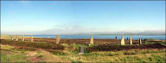
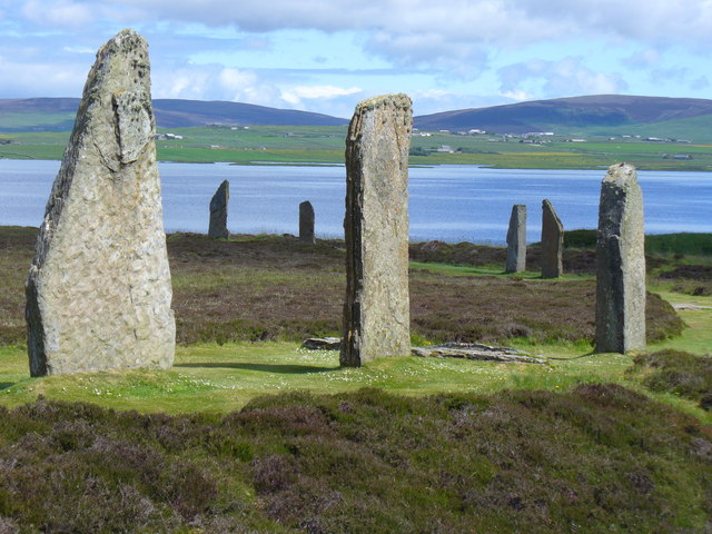
The Stones of Stenness you see and marvel at today are just a part of a ring of 12 tall stones and a surrounding ditch placed here some time between 3000BC and 2500BC. This was about the same time that nearby Maes Howe was being built, but well after Skara Brae was occupied and well before another stone circle was constructed a little to the north at the Ring of Brogar.
History has not treated the Stones of Stenness well. By the time Sir Walter Scott visited the site in August 1814, only four of the original stones were still standing and another was lying on the ground in the middle of the area. Scott drew the conclusion that this was an altar for human sacrifice.
On Christmas Day 1814 the local farmer, Captain MacKay, lost patience with the increasing stream of visitors tramping across his land to visit the stones. He destroyed the nearby "Stone of Odin" and toppled a second stone that was part of the ring before he was stopped. The Stone of Odin was an especially sad loss. It had a circular hole, through which local lovers plighted their troth by holding hands.
The Stones of Stenness passed into the care of the State in 1906. The stone that Captain MacKay had toppled was re-erected, as was another discovered lying under the turf. This rather small and misshapen stone has been the subject of controversy ever since, but it remains standing today. At the same time, the stone that Sir Walter Scott had described as an altar was raised on stone supports, so it looked like an altar. It was pushed off its supports one night in October 1972, apparently during a party.
Taking into account the digging of the long ploughed-out ditch and the erection of the stones themselves, some 5000 man-days would have been needed to build the stone circle here. This is only half what was later needed to construct the Ring of Brogar, but it still represents a huge investment of time and effort for purposes that are not completely understood.
When complete, the Stones of Stenness would have been a magnificent sight. The tallest of the stones still standing is 5.7m or 19ft high. Imagine the impact of three times as many of them.
And although the Stone of Odin was destroyed in 1814, there are other stones still standing in the area that were probably originally associated with the Stenness Stones. Most striking is the 6.5m Watch Stone overlooking the causeway a little to the north.
The Stones of Stenness are superbly located with wonderful views over the surrounding countryside extending to the hills of Hoy. The ideal time to visit is very early or late in the day in summer, when you can hope to see the stones against the sunrise or sunset, and maybe even have them to yourself.
Last edited by Graham; 07-19-2014 at 10:43 PM.
| Thumbs Up |
| Received: 19,706 Given: 5,850 |
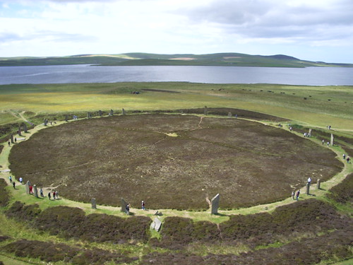
The Ring of Brogar is a stone circle superbly located on land rising above the saltwater Loch of Stenness and the freshwater Loch of Harray. When first erected there were 60 stones here, in a perfect circle 104m in diameter. Today just 36 of the original stones are still standing, and one of those only just, having been split vertically by a bolt of lightning on 5 June 1980.
The ring of stones is surrounded by a ditch cut into the rock that was 6m wide and 3m deep. There are entrance causeways across the ditch on the north-west side and on the south east-side.
It is thought that the Ring of Brogar was built between 2500BC and 2000BC. To put this in context, the earliest of these dates is about 600 years after Skara Brae was first occupied several miles to the west, about 300 years after Maes Howe was built, within sight to the south east, and probably some time after the Stones of Stenness had already been erected also within sight to the south.
Constructing the circle would have been a mammoth task. It has been estimated that it would have taken 10,000 man-days to dig the ditch alone, plus several thousand more man-days to find, transport and erect the stones.
Several hundred people could therefore have built the circle in one summer if they had done nothing else, or fewer people might have built it over a longer period of time.
Why would a society living on limited resources have spent so much effort building the Ring of Brogar? Was it a lunar observatory? Was it used for some unspecified ceremony?
Whatever the answer, and no-one really knows, it is certain it must have meant a great deal to the people who built it. So far only limited excavations have taken place at Brogar, so there's a great deal still to learn here.
When visiting, it is worth knowing that there is some confusion about the name of this monument. The Ordnance Survey, some road signs, and a number of well respected sources call it the "Ring of Brodgar". But Historic Scotland's current guides and signs on the site proclaim it as the Ring of Brogar, and that's the name we have used.
Possibly the most definitive of the signs bearing that name is the one greeting visitors walking through the gate from the road. This is the attractive marker denoting the Ring of Brogar as part of the Heart of Neolithic Orkney World Heritage Site, a designation that dates back to 1999.
| Thumbs Up |
| Received: 19,706 Given: 5,850 |
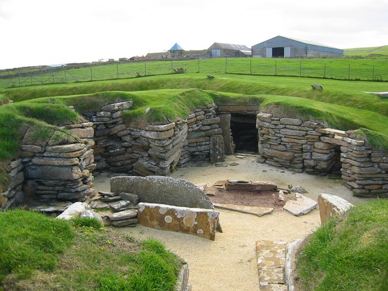
Skara Brae
Most people have heard of Skara Brae, and most will have seen it in image and in imagination long before visiting. As a result we approached it with some trepidation. A visit to Stonehenge many years ago produced the reaction: "is that all?" Magnificent it may have been, but the reality was nowhere near as magnificent as the expectations against which we were comparing it.
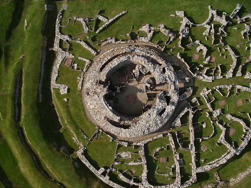
But there's no need to worry. The reality of Skara Brae exceeds expectations in many different ways. The site itself is larger and more impressive than can easily be captured in anything other than an aerial photograph. And the domestic details are deeply touching: you get an incredible sense of seeing into the day-to-day lives of the nameless people who lived here 5000 years ago.
And that is perhaps the most striking thing of all. After touring Skara Brae you have no difficulty realising that its inhabitants were people in many ways very similar to ourselves. Yes, they might have lived in a stone village half buried in a large pile of midden. But when you view the stone beds and dressers, the standardisation of the furnishings across the houses, the boxes in which they prepared their bait, you realise that if only we could know their names we could easily identify with these people and the lives they led.
The visit starts at the beautifully designed and built visitor centre, which is also home to a café and a well stocked shop.
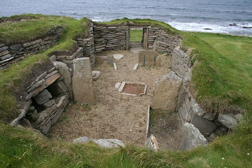
From here you move outside to be greeted by a surprise, a life-size recreation of one of the houses at Skara Brae in complete and "lived in" condition, all the way down to a fire burning in the hearth. It is worth curbing your impatience to see the real thing and spending a little time exploring this recreated house. It differs from those in the village primarily by being free-standing, and in having the one thing the others all lack: a roof.
The onward footpath leads out along part of Skaill Bay and is marked by a series of inscribed stones providing a timeline taking you all the way back to 3100BC, the date at which the village is thought to have been founded. And then you enter the village itself.
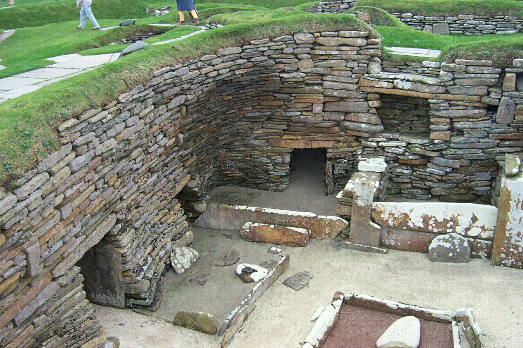
Skara Brae was built in at least two stages, and what you see today is mostly from the second stage of occupation. The residents built the village by forming a large pile of domestic rubbish, or midden. They then dug down into the pile of midden to create spaces for the houses and the passageways linking them, which they lined with stone.
If this creates a pretty unpleasant image, it's worth bearing in mind that domestic refuse in 3100BC would be fairly similar to garden compost today. We have no problem accepting that, after a suitable period, compost is a neutral material suitable for use on our gardens. It seems little different to suggest that in a largely sandy environment, midden would have been a ideally stable material in which to place a village, as well as a windproof one for such an exposed location.
The biggest surprise at Skara Brae is not the houses themselves, it is the way they are furnished. Each comes with a near identical set of fixtures and fittings. These include a large central hearth with a stone box bed on each side, with the bed on the right being larger than the bed on the left in each case. The box beds would have been packed with heather.
Each house is dominated by a stone-built dresser of standard size and design, and in some there is a stone seat in front of the dresser. The houses also contain a number of other storage areas, including shelves and recesses in the walls, and waterproof stone fish-bait boxes built into the floor.
One of the buildings, at the Historic Scotland office end of the site, is a little different, being free standing and without the same standard layout. It is thought to have been some sort of village workshop, separated from the rest of the settlement by a small open area.
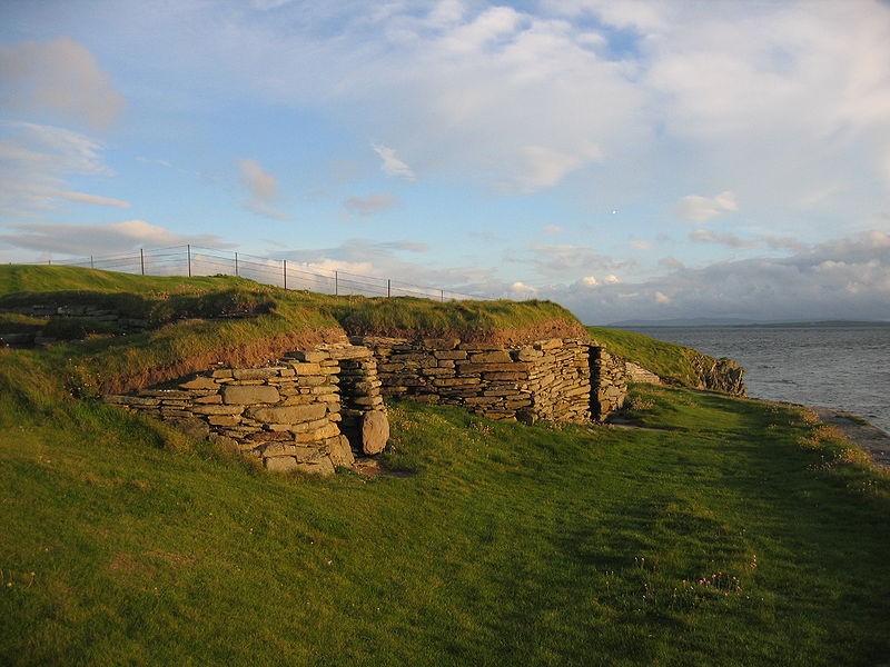
For many years, Skara Brae was believed to have been abandoned because a great storm covered it with sand in much the way another great storm in 1850 led to its discovery. The truth is probably less dramatic: that it was simply abandoned over a period of time as people's lives changed.
As time went on these early Orcadians increasingly co-operated together in larger groups and over larger areas, building monuments like Maes Howe and the Stones of Stenness.
After Skara Brae was abandoned it slowly filled with wind-blown sand and was then covered by it, ensuring its preservation in its current state. In 1850 the laird of nearby Skaill House, William Watt, realised the significance of what the storm had exposed, and work has been under way ever since both to protect the site and to explore it.
In 3100BC Skara Brae would have been some way inland. Today it lies right on the edge of Skaill Bay, protected from the sea only by the defences put there for that purpose. Skara Brae is in the care of Historic Scotland, and since December 1999 it has formed part of the Heart of Neolithic Orkney World Heritage Site.


| Thumbs Up |
| Received: 1 Given: 0 |
So much for "dumb primitive stone age man".


| Thumbs Up |
| Received: 23 Given: 1 |
All good but DO NOT VISIT Skara Brae it is awful, you are funnelled through a tourist tat shop, have to pay a ridiculous amount and get no guide or tour. Oh and they justify the price by saying you get admittance to the house next door, you do, but it is really not worth it. I would suggest the Broch of Gurness much better oh and go after 5 when it shuts, and you can have a poke around on your own, and go inside the walls, though don't if you are at all claustrophobic!
Cattle die, kinsmen die,
the self must also die;
but glory never dies,
For the one who is able to achieve it.
Sayings of the High One.


| Thumbs Up |
| Received: 25 Given: 8 |
Excellent and not a thing to do with Germanics! This is pre-Viking era, when the land was populated by Neolithic Atlanto-Mediterranean types.
| Thumbs Up |
| Received: 19,706 Given: 5,850 |
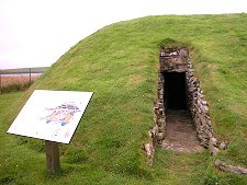
Broch of Gurness
Across the Highlands and Islands of Scotland there are around 500 brochs, circular defensive towers made of stone. Sometimes these stand alone, sometimes they form the focus of a community of smaller buildings. The shores of the Enyhallow Sound, between West Mainland and Rousay, are especially thickly populated with brochs. Two stand out as exceptional: Midhowe Broch on Rousay, and the Broch of Gurness, nearly opposite it on West Mainland.
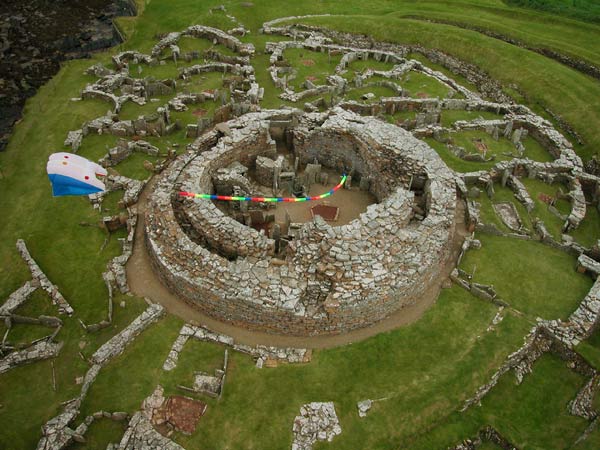
The Broch of Gurness was built as a planned settlement some time before 200BC. A circular area of nearly 50m in diameter was mapped out. Ditches were dug around the outer edges of the circle and ramparts were built with the spoil. The plan seems not to have been completed immediately, but within a fairly short time a broch was built, off centre within the inner ring of ditches defending the site.
Externally the broch was 20m in diameter and may have reached a height of 10m. Internally it was equipped with stone walls or dividers and a deep well. Around it was built a village of small stone houses, each with a yard and a storage shed. Over time, further modifications followed. The west side of the broch collapsed and had to be rebuilt, and other changes were made around the causeway bridging the ditches.
By about AD100 the population of the area had declined and the tower seems to have collapsed again. The inhabitants largely abandoned the site, leaving just one family who set up home amid the rubble in what has become known as the Shamrock House, because of the four rooms that lead off the central area. During the Pictish period in the AD500s-AD600s, this was also abandoned.
By the time the Vikings arrived in Orkney there was probably nothing at Gurness except for a grassy mound. At least one Viking was buried here, but there was otherwise no sign of any later disturbance or development until the site was excavated in 1929.
Today's Broch of Gurness still manages to give a sense of how it would have looked to its builders and original inhabitants. Over the intervening 2000 years the sea has swallowed up half of the land between the original north ditch and the outer edge of the broch. Further erosion has been checked by the building of a sea wall to protect the site.
The first structure encountered by the visitor is a 20th Century addition, the visitor centre. Opposite are the remains of the Shamrock House used by the Pictish family that lived here after the broch had fallen into disuse. This was originally found on the south side of the site but was moved to this position during the 1929 excavations.
Then you negotiate the concentric rings of ditches at what would have originally been the rear side of the broch, all the time approaching the remains of the main tower of the broch itself. This is at pretty much the height it was at when the archaeologists uncovered it in 1929, though what was originally a dry stone construction is today largely held together by mortar.
The village that surrounds the broch is more difficult to visualise than the broch itself, walls are low and in places fragmentary, and internal furnishings appear as sometimes little more than piles of stones. But it all starts to come together in an understandable way when you move around to the east side of the complex, where the entrance causeway that led from the outer defences of the site to the door of the broch can still be seen. And, still better, around it the shapes of the houses seem much clearer.
The causeway was probably designed to give an impressive or intimidating entrance to the complex in 200BC, and it remains impressive even today. Equally impressive is the doorway to the broch itself.
Because the upper levels of what was once a tall structure cannot be seen, it is difficult to gain a clear understanding of the way the broch would have been used. However, it is still possible to see the hearths on the floor. There are also many stone partitions, items of furniture and cupboards and cubbyholes. Within the thickness of the walls is a stone staircase that would originally have led to upper levels.
A particularly interesting feature is what the original archaeologists took to be a well in the floor of the broch, which had been filled in part way through the period of occupation. As this is a deep hole in the ground, with water at the bottom, it's a reasonable assumption to call it a well and believe that's the end of the story. The recent rediscovery of a rather spooky hole in the ground at Mine Howe has caused a rethink. Like Mine Howe, the well at Gurness has steps down into the interior and has chambers built into the its sides. No one yet has a convincing answer, but the idea that this was simply a broch well is now in doubt.
The Broch of Gurness is an intriguing place, and a tantalising one. Unlike Skara Brae, which predates it by around 3000 years, the evidence of the real people who built the broch always seems just out of reach. They certainly existed, but in wandering around the site today it's difficult to imagine them actually living out their day-to-day lives here. But despite that it really is a fascinating and intriguing place.
| Thumbs Up |
| Received: 19,706 Given: 5,850 |
A few other cool Places around that area:
At Knap of Howar on the Orkney island of Papa Westray, a Neolithic farmstead has been wonderfully well preserved, and is claimed to be the oldest preserved stone house in northern Europe, with radiocarbon dating showing that it was occupied from 3500 BC to 3100 BC, earlier than the very similar houses in the settlement at Skara Brae.
Unstan Chambered Cairn
Tomb of the Eagles
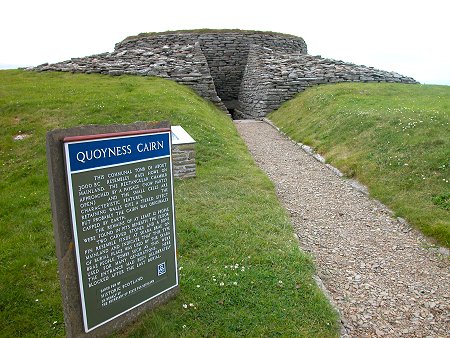
Quoyness Chambered Tomb or Cairn is one of the most impressive ancient monuments on Orkney. It lies near the east shore of Els Ness, an isolated promontory of land almost separated from the rest of Sanday. Els Ness is also home to a further 27 cairns of various sorts, suggesting this was a particularly important area for our Bronze Age ancestors who built the tomb some 5000 years ago.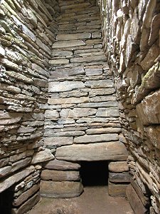
There are currently 1 users browsing this thread. (0 members and 1 guests)
 Posting Permissions

 Reply With Quote


Bookmarks